
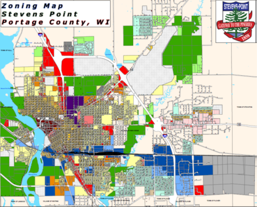
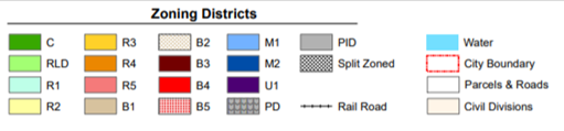
City of Stevens Point Zoning Districts
The following information displays the citywide zoning map for Stevens Point and the definitions of each zoning district. District abbreviations are used in the profiles of each Placemaking Hub in the Strategic Plan.
This district is established to protect environmentally sensitive lands such as flood plains, wetlands, shorelands, well fields, airport fringe lands, and fringe lands remote from City services and access. The district is also intended to be applied as a means of regulating the timing and direction of land development in accordance with the City’s Comprehensive Plan.
Zoning Definitions
This district is established to provide for low-density residential land usage and accessory uses particularly in fringe areas of the City to reduce the need for and costs of public services, such as sewer and water. Or, applied in those areas of the City where natural environmental conditions present physical development problems, such as groundwater, bedrock, clay soils, etc. A further purpose is to help preserve the open space and natural scenic and ecological qualities in special areas such as along shorelines, wetlands, bluffs, community parks, or other areas identified by the Plan Commission and otherwise consistent with the City’s Comprehensive Plan.
This district is established to provide for neighborhoods of moderate density single-family residential land usage and accessory uses. This district is to be located consistent with the City’s Comprehensive Plan.
This Hub is established to provide the population density and used primarily for single-family living, which is expected to accommodate the numerous residential developments already at the density of this district, and this district would accommodate other housing, not on City sewer. This district is to be located consistent with the City’s Comprehensive Plan.
This district is established to provide for both single-family residences and two-family residences intended particularly to act as a transition district between lower intensity uses such as permitted in “C”, “R-1” and “R-2” districts and higher intensity districts, consistent with the City’s Comprehensive Plan. This district is intended to be provided for all lands where sewer and water is or will be required.
This district is established to provide a medium density, mixed residential district intended to provide a transition between lower density detached housing areas and more intense non-residential land usage consistent with the City’s Comprehensive Plan.
This district is established to provide a mixed-use district of high-density living that permits hi-rise housing and also allows a variety of non-residential office-type or professional service uses. It is intended that this district will generally be accepted as a buffer use between lower density residential uses and commercial industrial uses, and in areas capable of handling higher traffic volumes and areas subject to higher land values than in lower-density residential zones with such districts located consistent with the City’s Comprehensive Plan.
The purpose of this district is to allow the development and redevelopment of residential land in the city consistent with the design principles of traditional neighborhoods. A traditional neighborhood is compact, designed for the human scale, and characterized by larger homes on smaller lots with smaller setbacks from the property lines.
This district is established to provide only those establishments which supply convenience goods and professional or personal services. These districts are intended to generally serve an area less than City-wide and to be allowed only at major traffic intersections and the total extent of such district to be limited to within an immediate zone of such intersections consistent with the City’s Comprehensive Plan.
It is intended that this district be applied on the fringe of the City’s Central Business district for the following purposes:
- To accommodate existing, new, and relocated land uses that are compatible with the retail core area.
- To provide a commercial district of intermediate intensity which will provide a buffer zone between the retail core and residential neighborhoods.
This district is established to provide a single contiguous district encompassing the central business district or downtown area which will encourage primarily retail uses and a variety of supporting uses. This district is intended to help implement the community’s specialized development goals and planning principles, for the CBD, particularly the development and maintenance of the downtown area as a specialized pedestrian-oriented shopping and community center.
This district is established to provide for retail, commercial, office, service, and apartment uses in areas of good accessibility along arterial streets consistent with the City’s Comprehensive Plan. This district is primarily intended to accommodate general commercial uses requiring on-site parking and arterial access.
This district is established to provide for larger retail, commercial, office, and service uses which depend upon access to major highways. This district is primarily intended to accommodate regional commercial uses requiring larger land areas than the “B-4” Commercial district and which depend upon region-wide usage and region-wide access. This district intends to provide for open space, to prevent congestion, to protect the highway corridor, to protect the safety of the users of the adjacent highway and the users of the commercial sites of this district, to protect property values, and to create a convenient and safe commercial area.
The purpose of this district is to allow the development and redevelopment of Tax Increment District 5 located generally along Division Street in the city consistent with the traditional commercial design principles. Traditional commercial design is compact, urban, and characterized by taller commercial buildings with smaller setbacks from the street.
This district is established to provide for those manufacturing or other industrial uses having the least obnoxious nuisance effects and having a lower intensity of activity as compared with permitted uses of the “M-2” Heavy Industrial District. It is intended that the “M-1” district be located as a buffer between heavy manufacturing uses and commercial or high-density residential uses or at other locations all consistent with the use planning principles, industrial location standards, and the City Comprehensive Plan and policies.
This district is established to provide for those manufacturing or other industrial uses having more obnoxious or nuisance effects than the “M-1” Light Industrial district and having a greater intensity of manufacturing, processing, employment, traffic, and other related activities. It is intended that the “M-2” district generally be located distant from non-manufacturing uses: that it be buffered by the “M-1” district or by major highways, rivers, open space, or high-intensity commercial uses, and that all “M-2” districts be located consistent with the City’s Comprehensive Plan.
Special Districts
The “U-1” University Facilities district is primarily intended to accommodate developed University-owned land and buildings and associated facilities.
Planned Development is a zoning district that allows for deviation from the standards of this zoning ordinance in exchange for higher quality development.
- Components of PD Approval: A PD approval consists of two separate steps:
- Approval of a rezoning and concept plan by the Plan Commission and Common Council; and
- Approval of subsequent subdivision plats and site plans consistent with the PD concept plan.
- When Allowed
- A PD is intended for projects that demonstrate a higher quality of site design that is more sensitive to the existing context, both built and natural, than is possible under other available zoning districts.
- All permitted and/or conditional uses found within the R-2, R-3, R-4, R-5, B-1, B-2, B-3, and B-4 zoning districts may be allowed as a permitted or conditional use.
This overlay district is established to maintain navigable air space over the aerial approaches in a condition best suited for the safe operation of aircraft.
The residents of the City of Stevens Point depend exclusively on groundwater for a safe drinking water supply. Certain land-use practices and activities can seriously threaten or degrade groundwater quality. The purpose of this Wellhead Protection Ordinance is to institute land use regulations and restrictions to protect the City’s municipal water supply and well fields, and to promote the public health, safety, and general welfare of the residents of the City of Stevens Point.
It is the purpose and intent of this Ordinance to regulate sexually oriented businesses to promote the health, safety, morals, and general welfare of the citizens of the City and to establish reasonable and uniform regulations to prevent any deleterious location of sexually oriented businesses within the City, thereby reducing or eliminating the adverse secondary effects from such sexually-oriented businesses.
The provisions of this Ordinance have neither the purpose nor effect of imposing a limitation or restriction on the content of any communicative materials, including sexually oriented materials. Similarly, it is not the intent nor effect of this ordinance to restrict or deny access by adults to sexually oriented materials protected by the First Amendment or to deny access by the distributors and exhibitors of sexually oriented entertainment to their intended market. Neither is it the intent nor effect of the ordinance to condone or legitimize the distribution of obscene material.
Proposed developments contemplated by an applicant to include design features described as “traditional neighborhood development” in Wisconsin Statutes Sec. 66.1027(1)(c) (1999-2000 Statutes) may be considered for approval at locations determined appropriate by the City under this section, including appropriate conditions.
A document identified as “A MODEL ORDINANCE FOR TRADITIONAL NEIGHBORHOOD DEVELOPMENT”, dated April 2001, published by the University of Wisconsin Extension pursuant to Wisconsin Statutes Sec. 66.1027(2), shall serve as a non-exclusive guidebook to assist in further defining the various aspects of this form of urban design, along with such other sources of guidance the Plan Commission and local governing body may choose to consult.
A Planned Industrial Development is a zoning district that is permitted within the Industrial districts. The district allows flexibility in site design and building type standards approved by the Common Council.
- Components of a PID: A PID approval consists of two separate steps:
- Approval of a rezoning and concept plan, by the Common Council; and
- The subsequent approval of a preliminary subdivision plat or site plan consistent with the PID concept plan by the Planning Commission.
- When Allowed
- A PID is intended for industrial projects that demonstrate a higher quality of site design that is more sensitive to the surrounding land uses, both built and natural, than is possible under other available zoning districts.
- All permitted and/or conditional uses found within the “M-1” Light Industrial and “M-2” Heavy Industrial zoning districts may be allowed as a permitted or conditional use.
Citywide Plans
There have been many plans completed for the City of Stevens Point, including several recent studies. When a plan was applicable to a specific Placemaking district, it was profiled in that section. However, key recent plans with citywide applicability are briefly listed in this Appendix.
Comprehensive Outdoor Park and Recreation Plan 2018 - 2022
Developed by SEH for the city in 2018, the document is the most recent update of the original 1971 plan. The update is intended to be a five-year guide for policy and financing decision-making for the city.
- Lands between Highway 66W and I-39 should be acquired for development as part of the Green Circle Trail.
- The Lynch, former Friday, and former Rachick properties adjacent to Bukolt Park should be acquired if they become available.
- Utilization of the City’s wellfield property for recreation should be continued and expanded.
- The lowland area of the landfill should be left as a wetland area and wildlife habitat.
- The City, County Parks Department, other governmental agencies, and Stevens Point Public School system should continue cooperation in planning parks, open spaces, and recreational facilities and programs.
- Develop a neighborhood park, south of Clark Street, west of Division Street, and east of the Wisconsin River. This will mitigate the park gap that currently exists within this area.
- Develop a park in the Riverview/Whiting Avenue area on the south side of Riverview Avenue between Echo Dells and the Wisconsin River to address the recreational needs of this new segment of Stevens Point.
- Support the future expansion of Schmeeckle Reserve.
- Develop a Community Park and several neighborhood parks east of I-39. Strong consideration should be given to the area east of Brilowski, south of Highway 10, north of Old 18, and west of County J. This area should have at least two small parks, one large community park, and a trail system linking them. This trail should link to the Green Circle Trail through the County Industrial Park.
- Develop a trail system along Country Club Road/Hoover to connect the existing Highway 66 bike trail adjacent to Iverson Park to the established Hoover Road bike trail in the Village of Plover.
- The City should consider acquiring land and/or easements for recreational lands adjacent to the Plover River, Wisconsin River, and Moses Creek area upstream from Michigan Avenue as it becomes available.
- Work with the School district on developing a park on the former Emerson School property.
- Support current and any future Bike/Ped, Riverfront, Green Circle Plans as adopted by the Common Council.
- Work on better identifying current public access along the Plover River corridor.
- Construct an underpass for the Green Circle Trail under the Canadian National tracks near the Wisconsin River and Wisconsin Street.
- Convert any abandoned rails to trails.
- The lighting of trails and other amenities should be done conservatively in recognition of maintaining Dark Skies.
Bukolt Park
- Consider update to Riverfront Plan. Given the recent improvements, private and public/institutional investments recently in downtown Stevens Point, the planning efforts to connect the riverfront and Bukolt Park to downtown should be re-evaluated.
- Continue to make efforts to prevent shoreline erosion.
Goerke Park
- Improve entrance road for clarity, including using landscaping to better delineate the entrance from the parking area.
- Create a buffer between parking and the western edge of the Park.
Improve signage. - Develop plans for improvements to the Aquatic Facility.
Iverson Park
- Continue tree plantings.
- Improve abandoned wellhouse.
- Inventory wildlife and plant species.
- Develop interpretive trails/natural areas.
- Re-establish channels through the park as needed.
- Replace the current restroom near the open shelter and ball diamond.
Koziczkowski Park
- Continue to work with the Audubon Society to develop a birding area.
Mead Park
- Improve the current swimming area.
- Develop trail along the Wisconsin River.
- Continue to support the Kids Are Special Here (KASH) playground.
Atwell Park
- Upgrade equipment as needed.
Hein Park
- Develop a Master Plan.
Morton Park
- Continue playground equipment replacement program.
- Buffer and landscape Park.
Slomann Park
- Continue playground equipment replacement program.
Texas Park
- Continue playground equipment replacement program.
- Consider installation of perimeter plantings.
McGlachlin Park
- Maintain passive, resting aspect of Park.
Riverwoods Park
- Preserve open space.
Veteran’s Memorial Park
- Buffer south and west side of Park from the parking area.
- Continue playground equipment replacement program.
Plover River Park
- Maintain the natural environment of this facility.
Pfiffner/Pioneer Park
- Consider update to Riverfront Plan. Given the recent improvements, private and public/institutional investments recently in downtown Stevens Point, the planning efforts to connect the riverfront and Pfiffner/Pioneer Park to downtown should be re-evaluated.
- Purchase or obtain a long-term easement of the Wisconsin Public Service property for future park expansion.
Zenoff Park
- Continue to work with Softball Association on improvements.
- Continue playground equipment replacement program.
Jelich Land
- Continue to develop and operate Sculpture Park.
Green Circle Trail
- Improve security for trail users.
- Explore additional trail extensions and converting from rails to trails.
- Continue working with the Green Circle Committee on upkeep and maintenance.
Conifer Park
- Continue playground equipment replacement program.
Parkwood Park
- Continue playground equipment replacement program.
Yulga Park
- Develop a Park Master Plan.
- Continue playground equipment replacement program.
Whitetail Park
- Continue to improve the disc golf course.
East Oaks Park
- Continue coordination with the Town of Hull.
- Continue playground equipment replacement program.
Soo Line Property
- Follow the current adopted plan.
Parkdale Park
- Develop a Master Plan for the Park.
- Work with neighbors and adjacent businesses on phasing in the park’s development.
2017 Stevens Point Comprehensive Plan Update
Beginning in 2014, the City of Stevens Point’s Community Development Department embarked on updating the City’s 2006 Comprehensive Plan. The first presentation regarding the update took place on August 13, 2014. A draft of the Update developed by SEH and dated 2017 has been posted on the city’s website (https://stevenspoint.com/DocumentCenter/View/4677).
The plan’s Goals, Objectives, and Policies support the four Guiding Principles for the Stevens Point Comprehensive Plan: Livable, Connected, Sustainable and Resilient. The goals are listed below. Objectives and tactics related to the goals can be found in the full Update draft.
LIVABLE
Goal 1: Prioritize recruitment of businesses to those that provide living-wage jobs.
Goal 2: Focus on creating a healthy City that provides for a quality of life that attracts and retains a creative, skilled labor force.
Goal 3: Work to improve the housing conditions throughout the City – particularly student housing and the availability of move-up housing.
CONNECTED
Goal 4: Continue to develop improved connections between Downtown and the Riverfront.
Goal 5: Strengthen and enhance existing business districts and commercial corridors.
Goal 6: Provide property located and designed neighborhood shopping facilities that offer opportunities for non-motorized commerce activities.
Goal 7: Support the development of commercial enterprises that serve or celebrate Stevens Point’s diverse cultures and people.
SUSTAINABLE
Goal 8: Create a regulatory review process that supports and encourages sustainable, private sector development.
Goal 9: Promote the efficient use of land and buildings.
Goal 10: Encourage compact and mixed-use development and redevelop
Goal 11: Continue to develop local renewable and energy efficiency resources.
Goal 12: Facilitate the development of a local food system.
RESILIENT
Goal 13: Continue to diversify the City’s economic base to improve resiliency to economic shocks and transformations that are outside the City’s control.
Goal 14: Foster an atmosphere that encourages and supports entrepreneurial activity.
Goal 15: Continue to develop and build out the City and County’s Business and Industrial Parks.
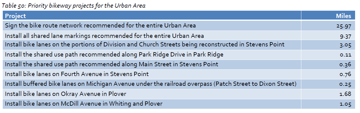
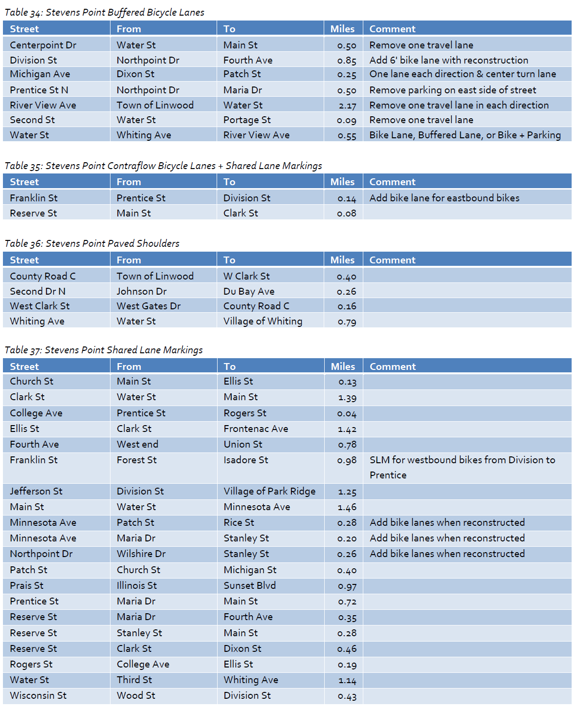
Portage County Countywide Bicycle and Pedestrian Plan
Produced by Toole Design Group and SAA Design Group and adopted in March 2014, the Countywide Bicycle & Pedestrian Plan consisted of two complementary elements – a Rural Area element and an Urban Area element that includes the City of Stevens Point, the Villages of Plover, Whiting, and Park Ridge, and portions of adjacent towns.
The plan identified ten priority recommendations for the Urban Area bikeway system listed in the following table.
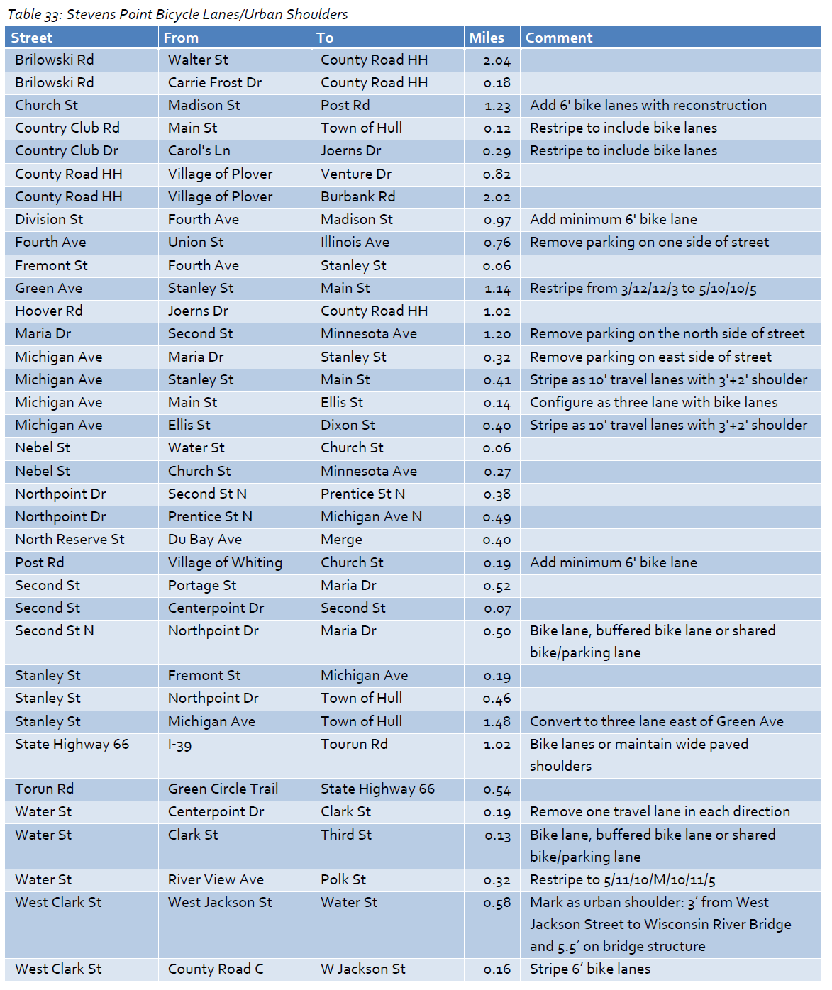
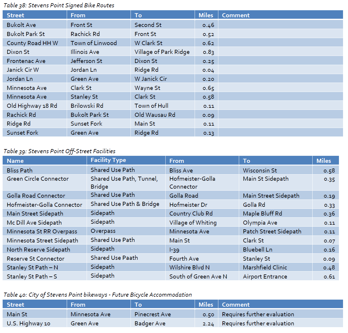
The plan also identified a series of specific bikeways for implementation.
The recommendations for the City of Stevens Point are found in the following tables.
Recommendations in the Safe Route to School portion of the Plan included a review of present policies and conditions as well as a biking and walking audit for each school and school neighborhood; a review of best practices being utilized to foster safe routes to school in other communities, and the preparation of recommendations and an action plan for each school and many neighborhoods in the county.
Specific recommendations for Stevens Point schools and neighborhoods can be found in the full draft of the Bicycle and Pedestrian Plan.