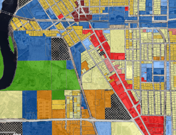
Existing Zoning and Land Uses
Central and South Point features the most diverse land use mix of all the Placemaking Hubs with a true hodgepodge of different categories. West of the Wisconsin River is Heavy Industrial districts intermixed with Conservancy land and Single and Two Family Residential parcels. In the north part of the district is the tail end of the Central Business (B3) district and Traditional Neighborhood Development Overlay District (R-TND) bordered on both sides by Single and Two-Family residential.
Clusters of Heavy Industrial (M2) parcels straddle the railroad tracks, interspersed with residential. Because the industrial quadrant around the south end of downtown is included in the R-TND overlay, there could be opportunities to convert existing buildings to residential uses if the projects qualify under the district guidelines.
Along Church and Water Streets north towards the train tracks and River View Avenue west to the river is an odd patchwork of uses ranging from Commercial to Single Family Residential, Multi-Family Residential I and II, Light and Heavy Industrial, and Split Zoned parcels. Some type of new overlay zone in Central and South Point enabling quality industrial and commercial conversions to residential and mixed-use development could be an effective way to upgrade the land uses in the district.
Proposed Areas of Focus
- Single-family residential; mixed-use; industrial mixed-use; residential and outdoor amenity, etc
- Old industrial spaces: Vetter Building, County Highway Building, Central City Market, cwACT*
Potential Policy Changes
- Create a new zoning district or overlay
- Create a new incentive district or tool [could have an application to multiple Hub Districts], etc.
15-Minute Neighborhoods
Via Strong Towns:
“A 15-minute neighborhood is a neighborhood in which you can access all of your most basic, day-to-day needs within a 15-minute walk of your home. It is also sometimes called a complete neighborhood.”